A customer service officer kindly gave us an overview of the Marina Barrage while we were browsing the information displays at the visitor centre. When she was done, I gingerly raised the question:
“Does the Marina Barrage have anything to do with the flooding Singapore’s been experiencing in recent years”?
Without missing a beat the young lady politely answered that they get that question a lot, and “no”, the Marina Barrage is not to blame for our recent flooding woes.
I’m a big fan of Singapore’s national water agency, the PUB for their visionary and genuinely envelope-pushing efforts in managing our country’s water needs (NEWater is ingenious, and I love the audacity of the Lorong Halus Wetland project). One can’t help but wonder though whether the Marina Barrage has somehow contributed to our flood situation.
THE LOWDOWN
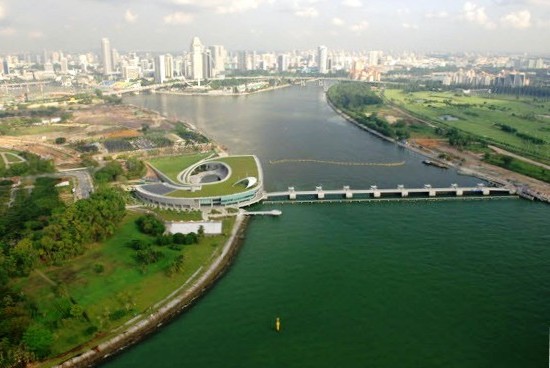
The Marina Barrage is a “3-in-1 project”: It chiefly dams up the Kallang Basin and estuary forming a freshwater reservoir after a couple of years through natural flushing by rainwater; it acts as a tide control barrier by keeping sea water out; and, it also features as an attractive downtown waterfront park and recreational space. Built at a cost of S$226 million, the Marina Barrage opened to much fanfare in November 2008.
Water from drains and canals flow into 5 main waterways, including the Kallang River and the Singapore River, which in turn feed into the Marina Reservoir. At 10,000 ha (hectares) the Marina Reservoir is the largest reservoir in Singapore, one-sixth of our land size, and serves as an important water catchment in meeting 10% of our current water needs.
Importantly the barrage is also the linchpin in a complex flood control system designed to alleviate flooding in low-lying city areas. If we experience heavy rain during a low tide the barrage’s 9 crest gates can simply be opened to release water from the reservoir out to sea. If it rains when the tide is high and sea levels outside are higher than within the reservoir, then 7 powerful drainage pumps can be activated to pump reservoir water into the sea.
When the Marina Barrage opened Singapore’s Ministry of the Environment and Water Resources (MEWR) announced that Singapore’s “flood-prone areas will be further reduced to less than 100 ha (1 square km)”. The drainage programme would also be accelerated “to manage unprecedented flash floods and this will further bring down the total flood-prone areas to less than 80 ha”.
This prediction has unfortunately turned out not to be true.
In November 2009, parts of Singapore saw its worst flood in decades after a heavy downpour. This prompted a minister to famously remark that we had experienced intense rainfall of an unprecedented “once in 50 years” magnitude, and the flash flood that resulted was unpreventable. In June 2010 however parts of our grand Orchard Road shopping belt became submerged during a heavy storm, and in the years to follow such intense rain and “freak flooding” in various parts of Singapore became an all too common occurrence. There is a Wikipedia page documenting Singapore’s floods from 2010 onward, and the PUB’s own Twitter account regularly tweets updates about rising water levels and flood alerts now.
Is it pure coincidence that Singapore is beginning to experience flooding reminiscent of life in the 1960s and 1970s post the Marina Barrage?
Some pundits have posited that the Marina Barrage has actually worsened our flooding situation rather than alleviated it. I also asked the customer service officer what mechanism determines when exactly the flood gates are opened (literally), and she replied that there was no automated system or anything to trigger the release of the reservoir waters, this was all done manually. I wonder then at what water levels in the reservoir do they decide to open the gates, and whether this is a constant level or would they further reduce the reservoir waters ahead of a big storm, in anticipation of the city’s network of drains, canals and rivers flooding quickly? And who makes the decision? For all you know our flooding might well be a result of the barrage operators not being proactive enough, or just being reluctant to release the precious reservoir waters.
Whatever the case, a panel of experts convened to examine the cause of the Great Orchard Road Flood of 2010 concluded that the floods were not caused by the Marina Barrage. An internet search will however interestingly show that elsewhere in other countries barrages or dams have been associated with increased flooding in upstream areas, demonstrating that you can’t always predict through data modelling and technical analysis exactly how water will flow.
What the PUB and other engineers also didn’t count on was Mother Nature switching things up. Blame it on Her for the increasingly heavy rainfall thwarting the barrage’s flood alleviation designs. A UN Panel on climate change recently reported that many tropical countries, Singapore included, can expect more “extreme rainfall”, and consequently flooding in the years to come.
Wellies may well become fashionable in Singapore one day.
VISITING
Hour-long guided tours of the 3-storey barrage centre are available, and you can book your tour slot online. There are 5 tours a day on weekdays (excluding Tuesdays), and 4 on weekends.
On the morning we visited all the tour slots were full however. As with many places in Singapore, schools frequently conduct field trips to places of interest, and hordes of school kids had descended there that day. Everywhere we went a school tour was in session.
We were offered a free audio guide however (in English although they might have other languages available), which was just as well. There was no shortage of information displays, and together with the commentary that guides you around the centre pointing out things of interest, I don’t really see a need to join the tour.
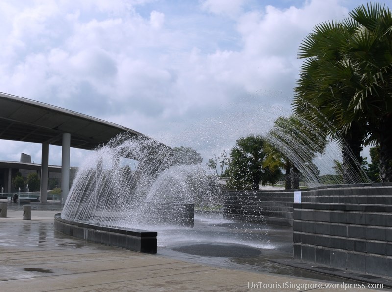
The barrage centre consists of a large courtyard housing several sculptures, as well as a “Water Playground” you can interact with. You get gorgeous views of the Singapore downtown skyline from this open concourse.
The large “Pump House” is on one side, and is glass-walled so you can have a peek at the gigantic pumps. 7 pumps which can each release the equivalent of an Olympic-sized pool of water (2500 cubic metres) in 1 minute are housed there.
The 2nd floor of the centre contains the “Sustainable Singapore Gallery”. Governmental agencies in Singapore seem particularly fond of these “galleries”, which are exhibitions featuring a wall-to-wall deluge of infographics, photos and videos, all lauding the agency’s efforts in moving the country forward. These make for great PR (public relations), and senior management and government leaders do love these self-congratulatory paeans. The gallery unabashedly bills itself as “an information and sensory extravaganza showcasing Singapore’s efforts towards environmental sustainability”.
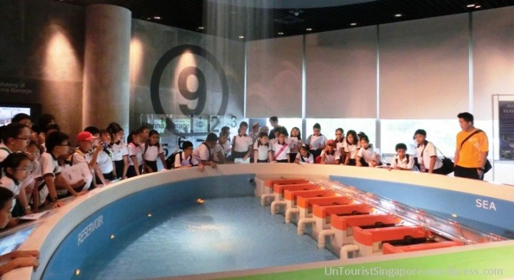
Well OK the gallery was informational and quite interesting. There are 6 sub-galleries within the gallery, and the highlight is probably Gallery 4 which contains a model of the Marina Barrage, complete with simulated rainfall and the disgorging of the dammed waters.
The top most floor of the building houses a “Green Roof”, and this is the most fun area. A broad green expanse also with fabulous views of the Marina downtown, it’s a favourite venue for kite flying. The green roof area also serves as a showcase for the centre’s environmental sustainability efforts.
There used to be a few restaurants in the centre however these have all closed.
The pièce de résistance of course is the actual barrage itself. You can take a scenic walk atop the 350m long barrage wall, and also to get a closer look at its 9 crest gates. You’ll notice the water within the reservoir and outside in the sea at different levels. If you’re game you can even walk all the way across the barrage to the lesser known Gardens by the Bay East, also known as Bay East Garden.
LOCATION
8 Marina Gardens Drive, just past Gardens by the Bay.
You can also access the barrage from the other side of the reservoir, via Gardens by the Bay East (Bay East Garden).
Information Counter: 9am – 9pm every day.
Sustainable Singapore Gallery: Open Wednesday to Monday, 9am – 9pm.
The centre and barrage itself are not gated, so you can actually visit any time. You can get great night time shots of the Marina Bay downtown.
HOW MUCH TIME
At least 2 hours to tour the barrage centre and stroll out onto the barrage, and to breeze through the Sustainable Singapore Gallery.
TIDBITS
- Former Prime Minister of Singapore Lee Kuan Yew is credited with the idea of damming the mouth of the Marina Channel to form a freshwater reservoir more than 30 years ago.
“In 20 years, it is possible that there could be breakthroughs in technology, both antipollution and filtration. Then we can dam up, or put a barrage at the mouth of the Marina, the neck that joins the sea. And we will have a huge fresh water lake.”
– Lee Kuan Yew, 1980.
- The barrage centre building is in the shape of the number “9”, perhaps in a nod to the 9 crest gates on the barrage, and also because “9” is a lucky number in Chinese culture. The design is also meant to resemble a seashell.
- Leading research and consultancy firm on environmental issues and utilities, WL Delft Hydraulics (now Deltares), was engaged by the PUB to consult on the Marina Barrage project. Being Dutch, they probably do know a thing or two about flooding and dams and dykes.
- The 5 km long Marina Coastal Expressway (MCE) includes an undersea tunnel which crosses the Marina Channel. At its deepest point the tunnel travels about 20 metres under the seabed. A stretch of the tunnel lies just 150 m away from the Marina Barrage.
TAKE NOTE
- School field trips usually take place in the mornings. Visit in the afternoon or evening instead.
- You can walk on the promenade by the water side to reach Satay by the Bay, the food court in Gardens by the Bay selling satay (delicious grilled meats on skewers) on push carts, and other local dishes.
- To be clear, when we talk about floods in Singapore we are not talking about the catastrophic flooding that occurs elsewhere in Asia, like the devastating Jan 2014 floods in Indonesia or in the Himalayas in India last year. At most we are talking traffic snarls, disrupted schedules and inconveniences here. In fact, when the Orchard Road floods happened the PUB had called it “ponding” (technically correct) and not “flooding”, although this was met with much derision from the public.
USEFUL LINKS


Pingback: Gardens by the Bay East: Tanjong Rhu Residents’ Secret | UnTourist Singapore
Click to access MCEAnnexA.pdf
http://www.onemotoring.com.sg/publish/onemotoring/en/on_the_roads/road_projects/construction_of_marina.html
http://en.wikipedia.org/wiki/2010%E2%80%9313_Singapore_floods
The timing of the construction and completion of the MCE seem to correlate with the some of the flooding episodes experience from 2010-2013.
One possible cause is the MCE construction actually block half the barrage flow output. This may significantly reduce the flow rate of the flood waters.
Hi ditti,
Good point and plausible explanation. Well we’ll see, hopefully with this season’s monsoon seeming to hit hard we won’t have a repeat of those floodings though.
MBev